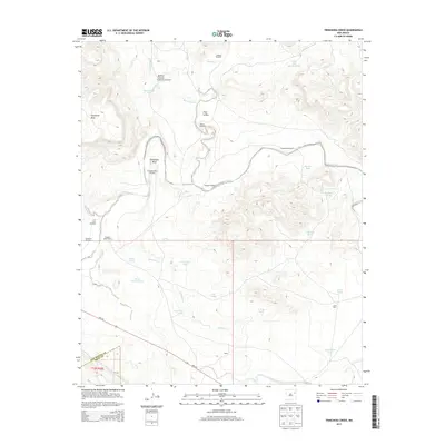
2013 Map of Trinchera Creek
USGS Topo · Published 2013About this map
Carpenter Mesa dominates the western topography of this high plains landscape, where the Canadian River cuts a prominent Horseshoe Bend as it flows eastward. This early 21st-century survey of the San Miguel and Quay County border region reveals a landscape defined by ranching infrastructure and seasonal water management. Named windmills, including the Artesian Windmill and Gartersnake Windmill, dot the terrain near drainage systems like Rattlesnake Cr and Mimosa Cr, providing vital water for local operations like the Chappell-Spade Ranch. The presence of numerous stock tanks, such as the Sink Hole Gap Stock Tank and Rockpile Tanks, alongside the Llano Pens, illustrates the specialized land use required in this arid environment. The map also traces the path of NM-104, the primary transit artery connecting these remote cattle ranges to larger settlements outside the quadrangle.
Find a feature on this map
43 named features on this map. Tap any name to fly to it.
Don’t see what you’re looking for? This feature index may not catch every label — zoom into the map to look around manually.
Map Details
Editions of this 2013 Trinchera Creek Map
This is the sole edition of this map. No revisions or reprints were ever made.
Other maps of this area

1930 · Tucumcari
USGS Topo · 1:125,000

1954 · Tucumcari
USGS Topo · 1:250,000

1958 · Tucumcari
USGS Topo · 1:250,000

1967 · Trinchera Creek
USGS Topo · 1:24,000

1967 · Liberty Mesa
USGS Topo · 1:24,000

1967 · Tucumcari
USGS Topo · 1:24,000

1968 · Bascom Camp
USGS Topo · 1:24,000

1968 · Hampton Ranch
USGS Topo · 1:24,000

1968 · Carpenter Mesa SW
USGS Topo · 1:24,000
1968 · Cow Canyon
USGS Topo · 1:24,000