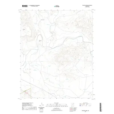
2020 Map of Trinchera Creek
USGS Topo · Published 2020About this map
The Canadian River cuts a prominent path through this high-desert landscape in northeastern New Mexico, defining the geographic character of the region. The map reveals an intricate network of drainage systems and watering points essential for ranching and land management, including numerous named stock tanks such as Sacaton Tank, Loma Cita Tank, and Government Tank. To the north, the terrain is shaped by the elevation of Carpenter Mesa and the winding course of Medina Canyon. The southern portion of the quadrangle is bisected by Trinchera Cr, which flows toward the border shared by San Miguel and Quay counties. This survey serves as a contemporary record of the natural landmarks and remote infrastructure that sustain the rural economy of this part of the state, centered on the unique bend of the river at Horseshoe Bend.
Find a feature on this map
27 named features on this map. Tap any name to fly to it.
Don’t see what you’re looking for? This feature index may not catch every label — zoom into the map to look around manually.
Map Details
Editions of this 2020 Trinchera Creek Map
This is the sole edition of this map. No revisions or reprints were ever made.
Other maps of this area

1930 · Tucumcari
USGS Topo · 1:125,000

1954 · Tucumcari
USGS Topo · 1:250,000

1958 · Tucumcari
USGS Topo · 1:250,000

1967 · Trinchera Creek
USGS Topo · 1:24,000

1967 · Liberty Mesa
USGS Topo · 1:24,000

1967 · Tucumcari
USGS Topo · 1:24,000

1968 · Bascom Camp
USGS Topo · 1:24,000

1968 · Hampton Ranch
USGS Topo · 1:24,000

1968 · Carpenter Mesa SW
USGS Topo · 1:24,000
1968 · Cow Canyon
USGS Topo · 1:24,000