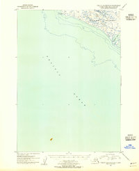
1954 Map of Trinity Islands D-2
USGS Topo · Published 1955About this map
Kodiak Island meets the expanse of the Pacific Ocean in this mid-century topographic record of Alaska's southwestern coastline. The map focuses on the shoreline of the Kodiak National Wildlife Refuge, where the terrestrial landscape is defined by the prominent Low Cape at the northern edge of the sheet. To the southeast, the protected waters of Sukhoi Bay provide a break in the exposed coastal frontage.
Find a feature on this map
5 named features on this map. Tap any name to fly to it.
Don’t see what you’re looking for? This feature index may not catch every label — zoom into the map to look around manually.
Map Details
Editions of this 1954 Trinity Islands D-2 Map
This is the sole edition of this map. No revisions or reprints were ever made.
Other maps of this area

1951 · Trinity Islands
USGS Topo · 1:250,000

1951 · Karluk
USGS Topo · 1:250,000

1952 · Karluk
USGS Topo · 1:250,000

1952 · Trinity Islands D-2
USGS Topo · 1:63,360

1952 · Trinity Islands D-1
USGS Topo · 1:63,360

1952 · Karluk A-1
USGS Topo · 1:63,360

1952 · Trinity Islands C-1
USGS Topo · 1:63,360

1952 · Karluk A-2
USGS Topo · 1:63,360
1954 · Karluk A-1
USGS Topo · 1:63,360

1954 · Trinity Islands C-1
USGS Topo · 1:63,360