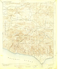
1921 Map of Triunfo Pass
USGS Topo · Published 1928About this map
Santa Monica Mountains dominate this coastal survey, where the steep topography of the Malibu shoreline meets the high peaks of Boney Mountain and Sandstone Pk. This 1920s landscape reveals the early transit patterns of coastal Ventura and Los Angeles counties, centered on the historic Triunfo Pass and the isolated settlement of Newbury Park. The map documents a network of canyons that carve through the range toward the Pacific Ocean, including Sycamore Canyon and Zuma Canyon, alongside the inland pastoral expanses of Conejo Valley and Russell Valley. Inland, small hubs like Triunfo and Cornell mark the limited development of the era, while the San Bernardino Base Line provides a fixed surveying reference across the complex terrain. The sharp distinction between the coastal canyons and the northern Simi Hills illustrates the geographic barriers that defined local travel before modern highway expansion.
Find a feature on this map
46 named features on this map. Tap any name to fly to it.
Don’t see what you’re looking for? This feature index may not catch every label — zoom into the map to look around manually.
Map Details
Editions of this 1921 Triunfo Pass Map
3 editions found
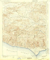
Other maps of this area

1900 · Triunfo Pass
USGS Topo · 1:62,500

1900 · Piru
USGS Topo · 1:62,500

1903 · Santa Paula
USGS Topo · 1:62,500

1903 · Calabasas
USGS Topo · 1:62,500

1903 · Camulos
USGS Topo · 1:125,000

1903 · Santa Susana
USGS Topo · 1:62,500

1904 · Hueneme
USGS Topo · 1:62,500

1921 · Piru
USGS Topo · 1:62,500

1921 · Triunfo Pass
USGS Topo · 1:62,500

1929 · Dume Point
USGS Topo · 1:24,000