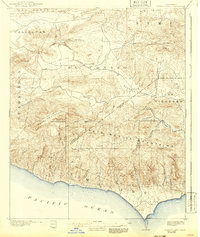
1921 Map of Triunfo Pass
USGS Topo · Published 1942About this map
Santa Monica Mountains dominate the southern half of this landscape, descending sharply to the Pacific Ocean along a coast defined by Dume Pt. This survey, based on data from 1900, reveals a sparsely populated region of Ventura and Los Angeles counties before modern coastal development. Small agricultural outposts and stage stops like Newbury Park and Triunfo anchor the inland valleys, connected by primitive roads through the El Conejo and Russell Valley. The complex topography is marked by significant peaks such as Sandstone Pk and Castro Pk, while deep drainage systems like Arroyo Sequit and Zuma Canyon carve their way to the sea. The map also delineates historical land divisions, including the San Bernardino Base Line and boundaries for large ranchos like Guadalasca and Las Virgenes.
Find a feature on this map
44 named features on this map. Tap any name to fly to it.
Don’t see what you’re looking for? This feature index may not catch every label — zoom into the map to look around manually.
Map Details
Editions of this 1921 Triunfo Pass Map
3 editions found
Other maps of this area

1900 · Triunfo Pass
USGS Topo · 1:62,500

1900 · Piru
USGS Topo · 1:62,500

1903 · Santa Paula
USGS Topo · 1:62,500

1903 · Calabasas
USGS Topo · 1:62,500

1903 · Camulos
USGS Topo · 1:125,000

1903 · Santa Susana
USGS Topo · 1:62,500

1904 · Hueneme
USGS Topo · 1:62,500

1921 · Piru
USGS Topo · 1:62,500

1921 · Triunfo Pass
USGS Topo · 1:62,500

1929 · Dume Point
USGS Topo · 1:24,000