
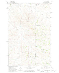
1974 Map of Trotters
USGS Topo · Published 1977About this map
Trotters marks the center of this 1970s landscape where the high plains of western North Dakota meet the rugged drainage basins of the Badlands. Straddling the boundary between McKenzie Co and Golden Valley Co, the area is defined by the complex branching of North Fork Smith Creek and South Fork Smith Creek. These waterways, along with Horse Creek and O'Neil Creek, carve deep coulees into the surrounding plateaus. Local community life is anchored by the Townhall and the South Side Cem, while the region's geology is evident in the scattered Scoria Pits and a Gravel Pit. The map captures a moment when this rural territory was organized by the large jurisdictional townships of Henry and Pearl, reflecting a sparse, ranch-oriented settlement pattern.
Find a feature on this map
13 named features on this map. Tap any name to fly to it.
Don’t see what you’re looking for? This feature index may not catch every label — zoom into the map to look around manually.
Map Details
Editions of this 1974 Trotters Map
This is the sole edition of this map. No revisions or reprints were ever made.
Other maps of this area

1909 · Glendive
USGS Topo · 1:250,000

1953 · Watford City
USGS Topo · 1:250,000

1954 · Glendive
USGS Topo · 1:250,000

1957 · Glendive
USGS Topo · 1:250,000

1957 · Watford City
USGS Topo · 1:250,000

1958 · Glendive
USGS Topo · 1:250,000

1967 · Watford City
USGS Topo · 1:250,000

1974 · Hootowl Creek West
USGS Topo · 1:24,000

1974 · Trotters SE
USGS Topo · 1:24,000
1974 · Skaar
USGS Topo · 1:24,000