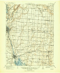
1914 Map of Troy
USGS Topo · Published 1950About this map
The Miami River corridor defines this portion of western Ohio, where the industrial and transport infrastructure of Troy and Piqua anchors the landscape. By the early twentieth century, the Miami and Erie Canal had already shaped the development of riverfront towns like Lockington and Eldean, while competing rail lines like the Cincinnati Hamilton and Dayton RR drove the region's growth.
Find a feature on this map
113 named features on this map. Tap any name to fly to it.
Don’t see what you’re looking for? This feature index may not catch every label — zoom into the map to look around manually.
Map Details
Editions of this 1914 Troy Map
2 editions found

Other maps of this area

1904 · Springfield
USGS Topo · 1:62,500

1904 · Dayton
USGS Topo · 1:62,500

1905 · Brookville
USGS Topo · 1:62,500

1906 · Dayton
USGS Topo · 1:62,500

1906 · Springfield
USGS Topo · 1:62,500

1909 · Loramie
USGS Topo · 1:62,500

1911 · Loramie
USGS Topo · 1:62,500

1911 · Covington
USGS Topo · 1:62,500

1913 · Bellefontaine
USGS Topo · 1:48,000

1913 · Sidney
USGS Topo · 1:62,500