
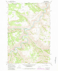
1967 Map of Troy
USGS Topo · Published 1971About this map
The confluence of the Wenaha River and the Grande Ronde River anchors this 1960s study of the borderlands between Oregon and Washington. The settlement of Troy sits at this junction, serving as a focal point for a landscape defined by deep canyons and high plateaus. To the north, the small community of Bartlett and the nearby Bartlett Cem provide evidence of early upland settlement patterns on the flat terrain above the river breaks. The map captures the complex topography of Wallowa County, where dramatic elevation changes lead from the river floor up to Day Ridge and Eden Ridge. Industrial and conservation markers are also present, including a Gravel Pit and the U S Fish and Wildlife River Gaging Sta, alongside the boundaries of the Umatilla National Forest.
Find a feature on this map
33 named features on this map. Tap any name to fly to it.
Don’t see what you’re looking for? This feature index may not catch every label — zoom into the map to look around manually.
Map Details
Editions of this 1967 Troy Map
2 editions found
Other maps of this area

1937 · Pomeroy
USGS Topo · 1:96,000

1942 · Pomeroy
USGS Topo · 1:125,000

1943 · Saddle Butte
USGS Topo · 1:62,500

1946 · Saddle Butte
USGS Topo · 1:62,500

1955 · Pullman
USGS Topo · 1:250,000

1955 · Grangeville
USGS Topo · 1:250,000

1958 · Pullman
USGS Topo · 1:250,000

1959 · Grangeville
USGS Topo · 1:250,000

1967 · Wood Butte
USGS Topo · 1:24,000

1967 · Eden
USGS Topo · 1:24,000