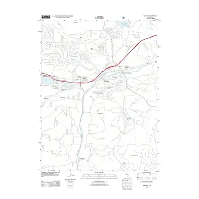
2012 Map of Truckee
USGS Topo · Published 2012About this map
Truckee serves as the central hub of this mountain corridor, where the Union Pacific Railroad and the Truckee River trace the valley floor toward Polaris. The landscape is defined by its recreation and infrastructure, from the Truckee-Tahoe Airport on the eastern flats to the Ponderosa Golf Course and Jim McIvers Memorial Arena near the town center. Local history is anchored by the Truckee Cemetery and the Murphy Cabin site near the eastern shore of Donner Lake. To the north, the Prosser Creek Reservoir and settlements like Prosser Lake Heights sit among the ridges of Prosser Hill. The southern reaches transition into timber and meadow lands, marked by the Old Schaeffer Mill and Old Schaeffer Camp along Martis Creek, illustrating the area's move from industrial logging roots toward a modern residential and alpine destination.
Find a feature on this map
100 named features on this map. Tap any name to fly to it.
Don’t see what you’re looking for? This feature index may not catch every label — zoom into the map to look around manually.
Map Details
Editions of this 2012 Truckee Map
This is the sole edition of this map. No revisions or reprints were ever made.
Other maps of this area

1891 · Truckee
USGS Topo · 1:125,000

1893 · Truckee
USGS Topo · 1:125,000

1895 · Truckee
USGS Topo · 1:125,000

1932 · Truckee
USGS Topo · 1:96,000

1940 · Truckee
USGS Topo · 1:125,000

1953 · Granite Chief
USGS Topo · 1:24,000

1953 · Granite Chief
USGS Topo · 1:62,500

1955 · Truckee
USGS Topo · 1:24,000
1955 · Kings Beach
USGS Topo · 1:24,000
1955 · Tahoe City
USGS Topo · 1:24,000