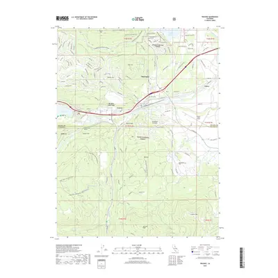
2018 Map of Truckee
USGS Topo · Published 2018About this map
Truckee serves as the central hub of this northern Sierra Nevada landscape, where the Truckee River and Donner Creek converge. The terrain is defined by a series of prominent peaks and flats, including Prosser Hill, Alder Hill, and Bald Mountain, which overlook a network of modern residential developments like Prosser Lakeview Estates and Ponderosa Palisades. This 2018 survey highlights the modern recreational and transit infrastructure of the Tahoe National Forest, from the Truckee-Tahoe Airport to a complex system of specialized paths such as the Prosser Hill Motorcycle trail and the Cabin Creek Loop Winter trail.
Find a feature on this map
47 named features on this map. Tap any name to fly to it.
Don’t see what you’re looking for? This feature index may not catch every label — zoom into the map to look around manually.
Map Details
Editions of this 2018 Truckee Map
This is the sole edition of this map. No revisions or reprints were ever made.
Other maps of this area

1891 · Truckee
USGS Topo · 1:125,000

1893 · Truckee
USGS Topo · 1:125,000

1895 · Truckee
USGS Topo · 1:125,000

1932 · Truckee
USGS Topo · 1:96,000

1940 · Truckee
USGS Topo · 1:125,000

1953 · Granite Chief
USGS Topo · 1:24,000

1953 · Granite Chief
USGS Topo · 1:62,500

1955 · Truckee
USGS Topo · 1:24,000
1955 · Kings Beach
USGS Topo · 1:24,000
1955 · Tahoe City
USGS Topo · 1:24,000