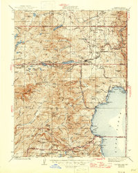
1940 Map of Truckee
USGS Topo · Published 1946About this map
The Southern Pacific railroad corridor serves as the industrial and logistical spine of this Sierra Nevada landscape, winding through the legendary Donner Pass toward the Truckee River canyon. At this mid-century point, established timber and transit hubs like Hobart Mills, Union Mills, and Floriston anchor the local economy, while the Victory Highway facilitates the growing motor-tourist traffic. The map details a transition from high-altitude industrial sites to the recreational developments appearing along the northern and western shores of Lake Tahoe.
Find a feature on this map
180 named features on this map. Tap any name to fly to it.
Don’t see what you’re looking for? This feature index may not catch every label — zoom into the map to look around manually.
Map Details
Editions of this 1940 Truckee Map
4 editions found

Other maps of this area

1889 · Pyramid Peak
USGS Topo · 1:125,000

1889 · Markleeville
USGS Topo · 1:125,000

1890 · Sierraville
USGS Topo · 1:125,000

1891 · Downieville
USGS Topo · 1:125,000

1891 · Carson
USGS Topo · 1:125,000

1891 · Markleeville
USGS Topo · 1:125,000

1891 · Colfax
USGS Topo · 1:125,000

1891 · Truckee
USGS Topo · 1:125,000

1891 · Reno
USGS Topo · 1:125,000

1891 · Placerville
USGS Topo · 1:125,000