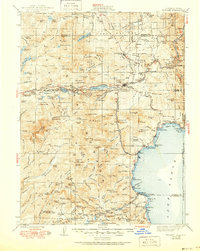
1940 Map of Truckee
USGS Topo · Published 1951About this map
The Southern Pacific Railroad cuts a winding path through the Sierra Nevada, anchoring timber and transit hubs like Truckee and Hobart Mills. This 1932 cultural revision captures the high country before modern development, showing the rugged corridor along the Victory Highway and the Little Truckee River. The map details the transition from industrial rail stops like Boca and Floriston to the growing recreational settlements along the western shore of Lake Tahoe, including Homewood and Meeks Bay. Significant landmarks of the era include the Johnson Monument and the early Airway Beacon network essential for mountain navigation. From the historic Henness Pass in the north to the resorts at Chambers Lodge, the map documents a landscape of high peaks like Mt Lola and Castle Peak interspersed with essential water resources like Independence Lake and Donner Lake.
Find a feature on this map
190 named features on this map. Tap any name to fly to it.
Don’t see what you’re looking for? This feature index may not catch every label — zoom into the map to look around manually.
Map Details
Editions of this 1940 Truckee Map
4 editions found

Other maps of this area

1889 · Pyramid Peak
USGS Topo · 1:125,000

1889 · Markleeville
USGS Topo · 1:125,000

1890 · Sierraville
USGS Topo · 1:125,000

1891 · Downieville
USGS Topo · 1:125,000

1891 · Carson
USGS Topo · 1:125,000

1891 · Markleeville
USGS Topo · 1:125,000

1891 · Colfax
USGS Topo · 1:125,000

1891 · Truckee
USGS Topo · 1:125,000

1891 · Reno
USGS Topo · 1:125,000

1891 · Placerville
USGS Topo · 1:125,000