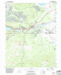
1992 Map of Truckee
USGS Topo · Published 1994About this map
The Truckee River corridor serves as the central artery for this mountainous region, where historic transportation routes and modern infrastructure converge near the Nevada Co Placer Co line. Significant cultural landmarks, such as the Donner Monument and the Murphy Cabin (Site) within Donner Memorial State Park, commemorate the area's difficult pioneer history. The landscape is defined by its transit heritage, featuring the Emigrant Road Trail and the Overland Trail alongside the active Southern Pacific railroad lines. Settlement patterns are concentrated around Truckee and Gateway, while the surrounding Tahoe National Forest contains remnants of early industrial activity like the Old Schaeffer Mill (Site). Large-scale landmarks including the Truckee-Tahoe Airport and the Prosser Creek Reservoir illustrate the mid-century evolution of this High Sierra hub.
Find a feature on this map
50 named features on this map. Tap any name to fly to it.
Don’t see what you’re looking for? This feature index may not catch every label — zoom into the map to look around manually.
Map Details
Editions of this 1992 Truckee Map
2 editions found
Other maps of this area

1891 · Truckee
USGS Topo · 1:125,000

1893 · Truckee
USGS Topo · 1:125,000

1895 · Truckee
USGS Topo · 1:125,000

1932 · Truckee
USGS Topo · 1:96,000

1940 · Truckee
USGS Topo · 1:125,000

1953 · Granite Chief
USGS Topo · 1:24,000

1953 · Granite Chief
USGS Topo · 1:62,500

1955 · Truckee
USGS Topo · 1:24,000
1955 · Kings Beach
USGS Topo · 1:24,000
1955 · Tahoe City
USGS Topo · 1:24,000