
1964 Map of True
USGS Topo · Published 1967About this map
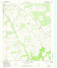
The Benson Oil Field and numerous scattered Oil Wells dominate this mid-century landscape in Young County, Texas, reflecting the region's intensive energy extraction. In the northwest corner, the town of Olney shows its mid-1960s footprint, featuring civic and social landmarks like the Athletic Field, Golf Course, and a Drive-in Theater along the main road. The drainage patterns of the area are defined by a complex network of waterways including Red Salt Creek, Willow Pond Creek, and Little Salt Creek, which carve through the terrain between active drilling sites.
Find a feature on this map
23 named features on this map. Tap any name to fly to it.
Don’t see what you’re looking for? This feature index may not catch every label — zoom into the map to look around manually.
Map Details
Editions of this 1964 True Map
2 editions found
Other maps of this area

1927 · Graham
USGS Topo · 1:62,500

1954 · Wichita Falls
USGS Topo · 1:250,000

1958 · Wichita Falls
USGS Topo · 1:250,000

1964 · Newcastle
USGS Topo · 1:24,000

1964 · Bobcat Bluff
USGS Topo · 1:24,000

1964 · Loving
USGS Topo · 1:24,000

1964 · Lake Eddleman
USGS Topo · 1:24,000
1964 · Prickly Pear Branch
USGS Topo · 1:24,000
1964 · Lake Olney
USGS Topo · 1:24,000

1964 · Olney
USGS Topo · 1:24,000