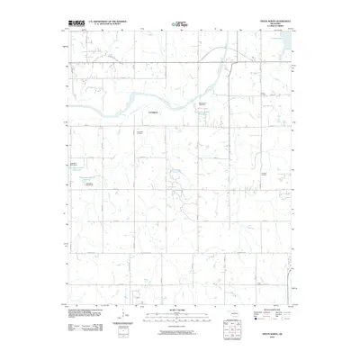
2010 Map of Tryon North
USGS Topo · Published 2010About this map
The Cimarron River winds through the heart of this landscape, its northern bank defined by the prominent Cimarron Bluff. This portion of Oklahoma north of Tryon is a study in rural organization and cultural heritage, featuring the settlement of Cottingham and a collection of significant community sites. For genealogists and local historians, the map identifies several burial grounds including Iowa Indian Cemetery, Parrott Cemetery, Oakdale Cemetery, and Osage Cemetery, each marking the generational footprints of the area's diverse inhabitants. Water management is a visible priority here, evidenced by Cushing Lake in the northeast and a series of numbered reservoirs such as Oknoname 11909 Reservoir and Oknoname 08117 Reservoir. The section-line road network, featuring routes like S Diamond Valley Rd and Mehan Rd, underscores the persistent agrarian structure of Lincoln and Payne counties.
Find a feature on this map
39 named features on this map. Tap any name to fly to it.
Don’t see what you’re looking for? This feature index may not catch every label — zoom into the map to look around manually.
Map Details
Editions of this 2010 Tryon North Map
This is the sole edition of this map. No revisions or reprints were ever made.
Other maps of this area

1893 · Stillwater
USGS Topo · 1:62,500

1908 · Agra
USGS Topo · 1:62,500

1909 · Perkins
USGS Topo · 1:62,500

1929 · Ripley
USGS Topo · 1:62,500

1932 · Ripley
USGS Topo · 1:62,500

1954 · Oklahoma City
USGS Topo · 1:250,000

1955 · Enid
USGS Topo · 1:250,000

1957 · Oklahoma City
USGS Topo · 1:250,000

1958 · Enid
USGS Topo · 1:250,000

1963 · Oklahoma City
USGS Topo · 1:250,000