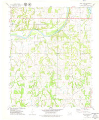
1975 Map of Tryon North
USGS Topo · Published 1979About this map
The Cimarron River carves a wide arc through this central Oklahoma landscape, defining the boundary between the Perkins and Cimarron townships. The mid-1970s landscape is marked by the persistent influence of energy and transport, with several Oil Wells and a Drill Hole scattered across the terrain. Rural life centers on small hubs like Tryon, Agra, and the settlement of Cottingham. The importance of local heritage is visible in the distribution of family and communal burial grounds, including the Iowa Indian Cem, Parrott Cem, and Osage Cem. Significant infrastructure such as the Missouri - Kansas - Texas rail line and various Pipelines cut across the drainage basins of Dugout Creek and Sand Creek, reflecting the region's historical role as a corridor for commodities and transit.
Find a feature on this map
33 named features on this map. Tap any name to fly to it.
Don’t see what you’re looking for? This feature index may not catch every label — zoom into the map to look around manually.
Map Details
Editions of this 1975 Tryon North Map
This is the sole edition of this map. No revisions or reprints were ever made.
Other maps of this area

1893 · Stillwater
USGS Topo · 1:62,500

1908 · Agra
USGS Topo · 1:62,500

1909 · Perkins
USGS Topo · 1:62,500

1929 · Ripley
USGS Topo · 1:62,500

1932 · Ripley
USGS Topo · 1:62,500

1954 · Oklahoma City
USGS Topo · 1:250,000

1955 · Enid
USGS Topo · 1:250,000

1957 · Oklahoma City
USGS Topo · 1:250,000

1958 · Enid
USGS Topo · 1:250,000

1963 · Oklahoma City
USGS Topo · 1:250,000