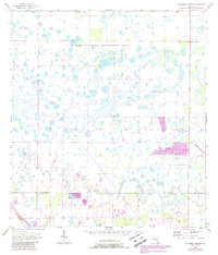
1957 Map of Tuckers Corner
USGS Topo · Published 1988About this map
The C M Webb Wildlife Management Area dominates this mid-century landscape in southwest Florida, preserving a complex network of wetlands and pine flatwoods. Originally mapped in the late 1950s, the sheet reveals a sparsely settled interior where hydrology dictated the early footprint of human activity. The boundary between Charlotte Co and Lee Co cuts across the southern portion of the quadrangle, illustrating the transition between these two coastal counties before modern suburban development pushed inland. Small nodes of activity like Tuckers Corner and Hickman are identified, along with a Fish Hatchery and the path of the Csx railroad. Updated purple revisions from the 1980s highlight changing land use, specifically indicating where woodland cover and strip mine areas have evolved since the original topographic surveys.
Find a feature on this map
6 named features on this map. Tap any name to fly to it.
Don’t see what you’re looking for? This feature index may not catch every label — zoom into the map to look around manually.
Map Details
Editions of this 1957 Tuckers Corner Map
3 editions found
Other maps of this area

1956 · Telegraph Swamp
USGS Topo · 1:24,000

1956 · Cleveland
USGS Topo · 1:24,000

1956 · Telegraph Swamp NW
USGS Topo · 1:24,000

1956 · Bermont
USGS Topo · 1:24,000

1956 · West Palm Beach
USGS Topo · 1:250,000

1957 · West Palm Beach
USGS Topo · 1:250,000

1957 · Tuckers Corner
USGS Topo · 1:24,000

1957 · Gilchrist
USGS Topo · 1:24,000

1958 · West Palm Beach
USGS Topo · 1:250,000

1958 · Fort Myers NW
USGS Topo · 1:24,000