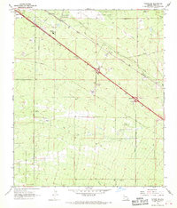
1968 Map of Tucson SE
USGS Topo · Published 1970About this map
The southeastern desert of the Tucson basin was defined by heavy infrastructure and defense operations in the late 1960s. Davis-Monthan Air Force Base occupies the northern edge, while the southern landscape is dominated by the Sahuarita Bombing and Gunnery Range. The Southern Pacific Railroad cuts a diagonal path through the desert, linking small rail-side settlements like Wilmot, Esmond, and Littletown. This period shows a complex network of resource management and logistics, evidenced by the prominent Pipeline corridors and the Aqueduct crossing the arid terrain. Local agricultural roots persist at Franco Ranch, but the area is increasingly industrial and public-facing, centered around the Pima County Fairgrounds and utility installations like the Nogales Substation. Numerous Gravel Pits and Borrow Pits mark the earth, signaling the physical material needs of regional expansion during this era.
Find a feature on this map
21 named features on this map. Tap any name to fly to it.
Don’t see what you’re looking for? This feature index may not catch every label — zoom into the map to look around manually.
Map Details
Editions of this 1968 Tucson SE Map
2 editions found
Other maps of this area

1904 · Patagonia
USGS Topo · 1:125,000

1904 · Tucson
USGS Topo · 1:125,000

1905 · Patagonia
USGS Topo · 1:125,000

1905 · Tucson
USGS Topo · 1:125,000

1926 · Helvetia
USGS Topo · 1:62,500

1948 · Tucson
USGS Topo · 1:62,500

1956 · Nogales
USGS Topo · 1:250,000

1956 · Tucson
USGS Topo · 1:250,000

1957 · Tucson East
USGS Topo · 1:24,000

1957 · Tucson
USGS Topo · 1:24,000