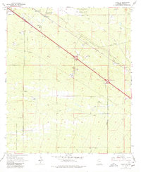
1968 Map of Tucson SE
USGS Topo · Published 1980About this map
The Southern Pacific Railroad cuts a diagonal path through this arid landscape southeast of Tucson, connecting small sidings and communities like Littletown, Wilmot, and Esmond. To the north, the massive footprint of the Davis-Monthan Air Force Base dominates the terrain, while the southern reaches are occupied by the Sahuarita Bombing and Gunnery Range. This period in the late 1960s shows a region transitioning from traditional ranching, represented by the Franco Ranch, to more modern infrastructure including a large Aqueduct, several pipelines, and the County Fairgrounds. The map details the early development of the interstate highway system through the area, noting several major interchanges such as the Wilmot Interchange and Rita Interchange, which would eventually reshape these desert settlements into modern suburbs.
Find a feature on this map
27 named features on this map. Tap any name to fly to it.
Don’t see what you’re looking for? This feature index may not catch every label — zoom into the map to look around manually.
Map Details
Editions of this 1968 Tucson SE Map
2 editions found
Other maps of this area

1904 · Patagonia
USGS Topo · 1:125,000

1904 · Tucson
USGS Topo · 1:125,000

1905 · Patagonia
USGS Topo · 1:125,000

1905 · Tucson
USGS Topo · 1:125,000

1926 · Helvetia
USGS Topo · 1:62,500

1948 · Tucson
USGS Topo · 1:62,500

1956 · Nogales
USGS Topo · 1:250,000

1956 · Tucson
USGS Topo · 1:250,000

1957 · Tucson East
USGS Topo · 1:24,000

1957 · Tucson
USGS Topo · 1:24,000