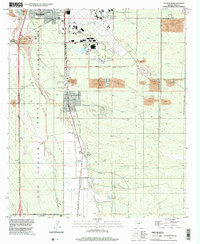
1996 Map of Tucson SW
USGS Topo · Published 2002About this map
Rancho De Martinez and the prominent Martinez Hill anchor the western portion of this Pima County landscape, which transitions from the industrial activity of the Tucson International Airport to the ancestral lands of the San Xavier Indian Reservation. The Santa Cruz River and its accompanying Santa Cruz Valley form the primary geographic spine of the sheet, flanked by a network of local infrastructure including the Filtration Plant and numerous Gravel Pit operations. Transportation routes like the Old Nogales Highway and Corona Road indicate the mid-century expansion of Tucson southward. Along the eastern edge, the Arizona State Prison Complex Bdy and a sprawling Firing Range reflect the institutional and military-adjacent land use common in this desert corridor during the late twentieth century.
Find a feature on this map
30 named features on this map. Tap any name to fly to it.
Don’t see what you’re looking for? This feature index may not catch every label — zoom into the map to look around manually.
Map Details
Editions of this 1996 Tucson SW Map
This is the sole edition of this map. No revisions or reprints were ever made.
Other maps of this area

1904 · Patagonia
USGS Topo · 1:125,000

1904 · Tucson
USGS Topo · 1:125,000

1905 · Patagonia
USGS Topo · 1:125,000

1905 · Tucson
USGS Topo · 1:125,000

1920 · Arivaca
USGS Topo · 1:125,000

1925 · Samaniego Peak
USGS Topo · 1:62,500

1925 · San Xavier
USGS Topo · 1:62,500

1926 · Helvetia
USGS Topo · 1:62,500

1934 · Tucson Mountains
USGS Topo · 1:125,000

1939 · Twin Buttes
USGS Topo · 1:62,500