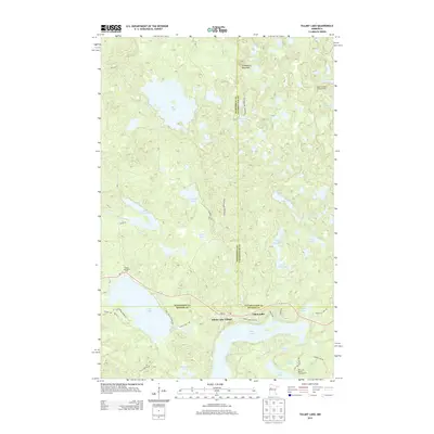
2013 Map of Tulaby Lake
USGS Topo · Published 2013About this map
Elbow Lake Village sits at the heart of this lake-strewn landscape where three counties meet: Mahnomen, Clearwater, and Becker. The terrain is defined by a dense concentration of glacial basins, ranging from the large expanses of Bass Lake and Tulaby Lake to smaller, secluded waters like Luethi Lake and Schantzen Lake. Evidence of fire management and forestry is visible at the Height of Land Lookout Tower near the eastern margin, while local recreation is centered around the Tulaby Lake Rest Area and the Pike Lake Resort Campground in the south. The road network, including MN-113 and Strawberry Mountain Rd, connects these scattered waterfront communities. Notable elevations like Strawberry Mountain provide a vertical contrast to the surrounding wetlands and drainage creeks such as Bear Cr and Bottom Cr.
Find a feature on this map
43 named features on this map. Tap any name to fly to it.
Don’t see what you’re looking for? This feature index may not catch every label — zoom into the map to look around manually.
Map Details
Editions of this 2013 Tulaby Lake Map
This is the sole edition of this map. No revisions or reprints were ever made.
Other maps of this area

1954 · Bemidji
USGS Topo · 1:250,000

1957 · Bemidji
USGS Topo · 1:250,000

1958 · Bemidji
USGS Topo · 1:250,000

1969 · North Twin Lake
USGS Topo · 1:24,000

1969 · Many Point Lake
USGS Topo · 1:24,000

1969 · Roy Lake
USGS Topo · 1:24,000

1969 · Tulaby Lake
USGS Topo · 1:24,000
1969 · Strawberry Lake
USGS Topo · 1:24,000

1969 · Snider Lake
USGS Topo · 1:24,000
1969 · Big Rush Lake
USGS Topo · 1:24,000