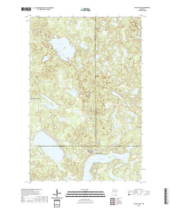
2022 Map of Tulaby Lake
USGS Topo · Published 2022About this map
Elbow Lake Village sits at the junction of three counties in this northern Minnesota lake country, where the borders of Mahnomen, Clearwater, and Becker counties converge. This water-rich landscape is defined by its glacial kettle lakes and wetlands, ranging from the large basin of Tulaby Lake to the more secluded Sawmill Lake and Little Elbow Lake. The terrain is punctuated by Strawberry Mtn, providing a subtle topographic break in an area otherwise dominated by basins like Bass Lake and Schantzen Lake. The map reveals a dense network of local access roads such as Bald Eagle Haven Rd and Fishermans Wharf Rd, illustrating the area's development for seasonal recreation and lakeside residency. Smaller water bodies like Johnson Lake, Wilson Lake, and Pike Lake further highlight the intricate hydrography that has shaped the local economy and settlement patterns.
Find a feature on this map
44 named features on this map. Tap any name to fly to it.
Don’t see what you’re looking for? This feature index may not catch every label — zoom into the map to look around manually.
Map Details
Editions of this 2022 Tulaby Lake Map
This is the sole edition of this map. No revisions or reprints were ever made.
Other maps of this area

1954 · Bemidji
USGS Topo · 1:250,000

1957 · Bemidji
USGS Topo · 1:250,000

1958 · Bemidji
USGS Topo · 1:250,000

1969 · North Twin Lake
USGS Topo · 1:24,000

1969 · Many Point Lake
USGS Topo · 1:24,000

1969 · Roy Lake
USGS Topo · 1:24,000

1969 · Tulaby Lake
USGS Topo · 1:24,000
1969 · Strawberry Lake
USGS Topo · 1:24,000

1969 · Snider Lake
USGS Topo · 1:24,000
1969 · Big Rush Lake
USGS Topo · 1:24,000