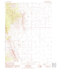
1986 Map of Tule Dam Spring
USGS Topo · Published 1987About this map
Diamond Valley and the Sulphur Spring Range dominate this landscape, illustrating the harsh basin-and-range environment of central Nevada in the late 1980s. The map captures a high-desert terrain defined by water scarcity and historical transit, where the Pony Expr Trail cuts across the sagebrush. Early industrial and ranching efforts are visible through the numerous prospects, a Mineshaft Dry Well, and a Gravel Pit.
Find a feature on this map
22 named features on this map. Tap any name to fly to it.
Don’t see what you’re looking for? This feature index may not catch every label — zoom into the map to look around manually.
Map Details
Editions of this 1986 Tule Dam Spring Map
This is the sole edition of this map. No revisions or reprints were ever made.
Other maps of this area

1926 · Roberts Mountains
USGS Topo · 1:250,000

1929 · Roberts Mountains
USGS Topo · 1:250,000

1949 · Garden Valley
USGS Topo · 1:62,500

1951 · Garden Valley
USGS Topo · 1:62,500

1953 · Eureka
USGS Topo · 1:62,500

1955 · Millett
USGS Topo · 1:250,000

1956 · Whistler Mtn
USGS Topo · 1:62,500

1956 · Ely
USGS Topo · 1:250,000

1957 · Diamond Springs
USGS Topo · 1:62,500

1959 · Ely
USGS Topo · 1:250,000