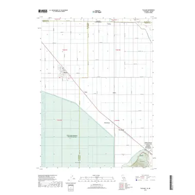
2018 Map of Tulelake
USGS Topo · Published 2018About this map
Tulelake serves as the primary hub for this fertile agricultural basin, where a rigorous grid of section roads like State Line Rd and Havilina Rd defines the landscape along the California-Oregon border. The region is characterized by significant federal land management, with the vast Tule Lake National Wildlife Refuge occupying the southwestern portion and the World War II Valor in the Pacific National Monument marking a site of profound historical weight in the southeast. Smaller settlements and rail-side stops including Stronghold, Homestead, and Tuber follow the diagonal track through the valley floor. Near the Klamath and Modoc County lines, the terrain rises toward The Peninsula and The Frog Pond, contrasting the flat, irrigated fields that dominate the Tule Lake basin. To the north, Malin Airport sits just across the state line, highlighting the cross-border connectivity of this high-desert community.
Find a feature on this map
53 named features on this map. Tap any name to fly to it.
Don’t see what you’re looking for? This feature index may not catch every label — zoom into the map to look around manually.
Map Details
Editions of this 2018 Tulelake Map
This is the sole edition of this map. No revisions or reprints were ever made.
Other maps of this area

1886 · Modoc Lava Bed
USGS Topo · 1:250,000

1889 · Klamath
USGS Topo · 1:250,000

1892 · Modoc Lava-Bed
USGS Topo · 1:250,000

1894 · Klamath
USGS Topo · 1:250,000

1950 · Mt. Dome
USGS Topo · 1:62,500

1951 · Tulelake
USGS Topo · 1:62,500

1954 · Alturas
USGS Topo · 1:250,000

1955 · Klamath Falls
USGS Topo · 1:250,000

1957 · Merrill
USGS Topo · 1:62,500

1957 · Malin
USGS Topo · 1:62,500