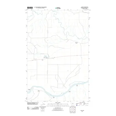
2011 Map of Tunis
USGS Topo · Published 2011About this map
The Missouri River and Teton River carve through this section of Chouteau County, creating a landscape defined by dramatic drainage systems. The small settlement of Tunis serves as a central point in this rural expanse, located near Eightmile Springs and the Eightmile Spring Dam. The topography is characterized by a series of deep ravines or coulees that lead toward the riverbanks, including Bullhead Coulee, Cherry Coulee, and Long Coulee to the south, and Eightmile Coulee to the north. This network of waterways and springs suggests the vital role of water management in this high-plains environment, connected by a modest grid of ranch roads such as Elbow Ranch Rd and Spring Station Rd. The map illustrates the sparsely populated but highly organized nature of Montana's river valleys in the early 21st century.
Find a feature on this map
15 named features on this map. Tap any name to fly to it.
Don’t see what you’re looking for? This feature index may not catch every label — zoom into the map to look around manually.
Map Details
Editions of this 2011 Tunis Map
This is the sole edition of this map. No revisions or reprints were ever made.
Other maps of this area

1890 · Fort Benton
USGS Topo · 1:250,000

1892 · Fort Benton
USGS Topo · 1:250,000

1897 · Fort Benton
USGS Topo · 1:250,000

1953 · Carter
USGS Topo · 1:24,000

1953 · Tunis
USGS Topo · 1:24,000

1954 · Great Falls
USGS Topo · 1:250,000

1954 · Rice Reservoir
USGS Topo · 1:24,000

1954 · Fort Benton
USGS Topo · 1:24,000

1954 · Lander Crossing
USGS Topo · 1:24,000

1956 · Highwood
USGS Topo · 1:62,500