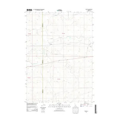
2013 Map of Tunupa
USGS Topo · Published 2013About this map
The Little Wood River meanders across the high desert landscape of Idaho's Snake River Plain, marking a contrast between the dry terrain and the extensive irrigation network that sustains the region's agriculture. This 2013 survey details the vital water infrastructure defining the border between Gooding and Lincoln Counties, including the S Gooding Main Canal and several distribution channels like Lateral 916C and Lateral B 1. The small settlement of Tunupa sits central to this network, situated near Sliman Reservoir. While the Us-26 E provides modern access, the presence of the Old Gooding Hwy and local thoroughfares such as Arcush Rd and Olinger Rd reflect the enduring pathways established by early settlers to connect these dispersed ranching and farming outposts.
Find a feature on this map
19 named features on this map. Tap any name to fly to it.
Don’t see what you’re looking for? This feature index may not catch every label — zoom into the map to look around manually.
Map Details
Editions of this 2013 Tunupa Map
This is the sole edition of this map. No revisions or reprints were ever made.
Other maps of this area

1955 · Twin Falls
USGS Topo · 1:250,000

1955 · Hailey
USGS Topo · 1:250,000

1957 · Thorn Creek SE
USGS Topo · 1:24,000

1957 · Thorn Creek SW
USGS Topo · 1:24,000

1957 · Thorn Creek
USGS Topo · 1:62,500

1958 · Twin Falls
USGS Topo · 1:250,000

1959 · Hailey
USGS Topo · 1:250,000

1962 · Hailey
USGS Topo · 1:250,000
1971 · Wendell
USGS Topo · 1:24,000

1971 · Tunupa
USGS Topo · 1:24,000