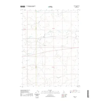
2020 Map of Tunupa
USGS Topo · Published 2020About this map
The small settlement of Tunupa sits at the center of this landscape in southern Idaho, where the high desert meets a complex network of agricultural irrigation. The Big Wood River and Little Wood River traverse the region, their waters diverted through an intricate system of canals and laterals, including the S Gooding Main Canal and the precisely named Lateral 926C1B. This hydraulic engineering is further evidenced by Sliman Reservoir and the Arkoosh Hydro facility, highlighting the importance of water management in the Snake River Plain.
Find a feature on this map
21 named features on this map. Tap any name to fly to it.
Don’t see what you’re looking for? This feature index may not catch every label — zoom into the map to look around manually.
Map Details
Editions of this 2020 Tunupa Map
This is the sole edition of this map. No revisions or reprints were ever made.
Other maps of this area

1955 · Twin Falls
USGS Topo · 1:250,000

1955 · Hailey
USGS Topo · 1:250,000

1957 · Thorn Creek SE
USGS Topo · 1:24,000

1957 · Thorn Creek SW
USGS Topo · 1:24,000

1957 · Thorn Creek
USGS Topo · 1:62,500

1958 · Twin Falls
USGS Topo · 1:250,000

1959 · Hailey
USGS Topo · 1:250,000

1962 · Hailey
USGS Topo · 1:250,000
1971 · Wendell
USGS Topo · 1:24,000

1971 · Tunupa
USGS Topo · 1:24,000