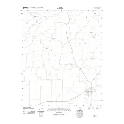
2010 Map of Turkey
USGS Topo · Published 2010About this map
Turkey sits at the southern edge of this West Texas landscape, where the town’s grid meets a network of rural roads such as Co RD 2 and FM 3323. The terrain to the north is defined by the carved paths of the Little Red River and Indian Arroyo, alongside prominent breaks like Pole Canyon and Gyp Canyon. Water management is central to the land's utility, evidenced by a series of named tanks and windmills that supported ranching operations across the plains. Notable landmarks include the Burson Lake Dam and several isolated windmills with family or local identifiers, such as Fuston Camp Windmill and Big Mule Creek Windmill. The map captures the specialized infrastructure of the Panhandle, where features like Old Cottonwood Tank and New Cottonwood Tank provided essential water sources in an area marked by seasonal flows like Lost Mule Creek and Hackberry Creek.
Find a feature on this map
39 named features on this map. Tap any name to fly to it.
Don’t see what you’re looking for? This feature index may not catch every label — zoom into the map to look around manually.
Map Details
Editions of this 2010 Turkey Map
This is the sole edition of this map. No revisions or reprints were ever made.
Other maps of this area

1954 · Plainview
USGS Topo · 1:250,000

1958 · Plainview
USGS Topo · 1:250,000

1960 · Indian Peak
USGS Topo · 1:62,500

1960 · Brice
USGS Topo · 1:62,500

1967 · Quitaque
USGS Topo · 1:24,000

1967 · North Windmill
USGS Topo · 1:24,000

1967 · Tampico Siding
USGS Topo · 1:24,000

1967 · Turkey
USGS Topo · 1:24,000

1967 · Lake Theo
USGS Topo · 1:24,000
1967 · Folley
USGS Topo · 1:24,000