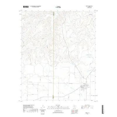
2019 Map of Turkey
USGS Topo · Published 2019About this map
The town of Turkey serves as the focal point of this North Texas landscape, where the flat plains of Hall County give way to the complex drainage systems of the Caprock region. The grid-pattern streets of the settlement, including Main St and Estelline Ave, transition abruptly into a rural network of county roads and historical pathways. The northern portion of the map is defined by the winding course of the Little Red River, which has carved intricate relief through Pole Canyon and Gyp Canyon. This rugged topography is dotted with local water sources like Burson Lake, Pole Tank, and Timmons Tank, illustrating the vital role of water management for ranching and agriculture in this semi-arid environment. The boundary between Briscoe and Hall counties bisects the terrain, marked by long-standing routes such as the Kent Creek Trail and Oxbow Trail that follow the natural contours of Turkey Creek and its tributaries.
Find a feature on this map
49 named features on this map. Tap any name to fly to it.
Don’t see what you’re looking for? This feature index may not catch every label — zoom into the map to look around manually.
Map Details
Editions of this 2019 Turkey Map
This is the sole edition of this map. No revisions or reprints were ever made.
Other maps of this area

1954 · Plainview
USGS Topo · 1:250,000

1958 · Plainview
USGS Topo · 1:250,000

1960 · Indian Peak
USGS Topo · 1:62,500

1960 · Brice
USGS Topo · 1:62,500

1967 · Quitaque
USGS Topo · 1:24,000

1967 · North Windmill
USGS Topo · 1:24,000

1967 · Tampico Siding
USGS Topo · 1:24,000

1967 · Turkey
USGS Topo · 1:24,000

1967 · Lake Theo
USGS Topo · 1:24,000
1967 · Folley
USGS Topo · 1:24,000