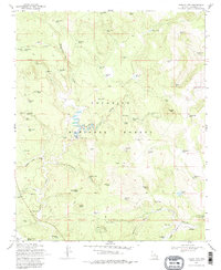
1970 Map of Turkey Mtn.
USGS Topo · Published 1979About this map
Coconino National Forest defines this high-country landscape, where 1970s land management is visible through an extensive network of water tanks and cattle infrastructure. The geography is carved by prominent drainage systems like Willow Valley, Antelope Draw, and Bargaman Draw, which reveal the critical importance of water conservation in the Arizona backcountry. Named landmarks such as Turkey Mtn and Oak Hill rise above the terrain, while the map records specific local features like the Bar O Corral and the Wingfield Corral. This survey captures the transition of the region through its nomenclature, featuring curiously named watering points like Foot In Tree Tank, Two Jim Tank, and the secluded Lost Eden near Jacks Canyon. For those tracing local ranching history, the distribution of corrals and jeep trails illustrates how this part of Coconino County was navigated and utilized before modern development.
Find a feature on this map
79 named features on this map. Tap any name to fly to it.
Don’t see what you’re looking for? This feature index may not catch every label — zoom into the map to look around manually.
Map Details
Editions of this 1970 Turkey Mtn. Map
3 editions found
Other maps of this area

1887 · Verde
USGS Topo · 1:250,000

1892 · Verde
USGS Topo · 1:250,000

1954 · Holbrook
USGS Topo · 1:250,000

1957 · Holbrook
USGS Topo · 1:250,000

1958 · Holbrook
USGS Topo · 1:250,000

1960 · Holbrook
USGS Topo · 1:250,000
1965 · Long Valley
USGS Topo · 1:24,000
1965 · Calloway Butte
USGS Topo · 1:24,000
1965 · Hutch Mtn.
USGS Topo · 1:24,000
1965 · Blue Ridge Reservoir
USGS Topo · 1:24,000