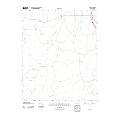
2010 Map of Turkey
USGS Topo · Published 2010About this map
The town of Turkey and the nearby community of Moltonville center this coastal plain landscape in Duplin County, defined by a dense network of creek-fed mills and local road systems. This modern survey illustrates the persistent importance of watercourses such as Six Runs Creek and Stewarts Creek, where historical crossings like Kirbys Bridge and Reeds Ford Bridge maintain the area's rural connectivity. Aviation activity is noted at the uniquely named Yam Yankees Airport west of Elliott, while long-standing local landmarks like New Hope Cemetery provide points of interest for genealogists tracing family histories in the region. The map reveals a transition of nomenclature from the larger settlements to smaller locales like Baltic, all tied together by names that reflect a long history of water-powered industry, including Carltons Mill Run and Sikes Mill Run.
Find a feature on this map
61 named features on this map. Tap any name to fly to it.
Don’t see what you’re looking for? This feature index may not catch every label — zoom into the map to look around manually.
Map Details
Editions of this 2010 Turkey Map
This is the sole edition of this map. No revisions or reprints were ever made.
Other maps of this area

1909 · Coharie
USGS Topo · 1:62,500

1953 · Florence
USGS Topo · 1:250,000

1953 · Raleigh
USGS Topo · 1:250,000

1954 · Florence
USGS Topo · 1:250,000

1954 · Raleigh
USGS Topo · 1:250,000

1959 · Garland
USGS Topo · 1:62,500

1962 · Rose Hill
USGS Topo · 1:62,500

1975 · Faison
USGS Topo · 1:24,000
1977 · Warsaw North
USGS Topo · 1:24,000

1982 · Elizabethtown
USGS Topo · 1:100,000