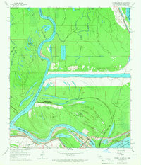
1965 Map of Turnbull Island
USGS Topo · Published 1966About this map
Turnbull Island is defined by its position within the complex hydrologic network of the Red River and the Upper Old River at the boundary of Louisiana and Mississippi. The landscape is a labyrinth of oxbows and backwaters, including Moreau Lake, Grand Lake, and Gibson Lake, illustrating the dynamic nature of these river systems. Small-scale development is concentrated in the southern section, where the Oak Grove Ch and Royal Oak Ch stand as community anchors alongside the Turnbull Cem. A massive Outflow Channel cuts across the center of the sheet, signaling the significant water management infrastructure required to control this flood-prone region. The presence of an Old Railroad Grade near Alligator Bayou suggests an earlier era of industrial transit through the bottomlands that had already faded by the mid-1960s.
Find a feature on this map
50 named features on this map. Tap any name to fly to it.
Don’t see what you’re looking for? This feature index may not catch every label — zoom into the map to look around manually.
Map Details
Editions of this 1965 Turnbull Island Map
3 editions found
Other maps of this area

1939 · Artonish
USGS Topo · 1:62,500

1941 · Voorhies
USGS Topo · 1:62,500

1941 · Batchelor
USGS Topo · 1:62,500

1953 · Natchez
USGS Topo · 1:250,000

1954 · Artonish
USGS Topo · 1:62,500

1954 · Baton Rouge
USGS Topo · 1:250,000

1955 · Artonish
USGS Topo · 1:62,500

1955 · Batchelor
USGS Topo · 1:62,500

1955 · Odenburg
USGS Topo · 1:62,500

1956 · Natchez
USGS Topo · 1:250,000
Featured Places
- Merrick, LA
- Avoyelles Parish, LA
- Pointe Coupee Parish, LA
- Concordia Parish, LA
- West Feliciana Parish, LA