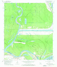
1965 Map of Turnbull Island
USGS Topo · Published 1975About this map
Turnbull Island dominates this 1960s landscape, carved out by the shifting hydrologic patterns of the Red River and the Mississippi River. The map captures a complex network of backwaters and bayous, including Moreau Lake and Grand Lake, illustrating the dynamic nature of the alluvial plain. Historical land use is evident in the presence of the Old Railroad Grade and infrastructure such as the Old River Lock and the substantial Outflow Channel. Local history and genealogy are anchored by specific landmarks like the Turnbull Cem and the Royal Oak Ch. Smaller water bodies, such as Les Petites Lacs a Blakewood and Sugar Mill Chute, reflect the localized geography of the parish boundaries where Avoyelles Parish, Concordia Parish, and West Feliciana Parish meet.
Find a feature on this map
49 named features on this map. Tap any name to fly to it.
Don’t see what you’re looking for? This feature index may not catch every label — zoom into the map to look around manually.
Map Details
Editions of this 1965 Turnbull Island Map
3 editions found
Other maps of this area

1939 · Artonish
USGS Topo · 1:62,500

1941 · Voorhies
USGS Topo · 1:62,500

1941 · Batchelor
USGS Topo · 1:62,500

1953 · Natchez
USGS Topo · 1:250,000

1954 · Artonish
USGS Topo · 1:62,500

1954 · Baton Rouge
USGS Topo · 1:250,000

1955 · Artonish
USGS Topo · 1:62,500

1955 · Batchelor
USGS Topo · 1:62,500

1955 · Odenburg
USGS Topo · 1:62,500

1956 · Natchez
USGS Topo · 1:250,000
Featured Places
- Merrick, LA
- Avoyelles Parish, LA
- Pointe Coupee Parish, LA
- Concordia Parish, LA
- West Feliciana Parish, LA