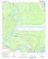
1965 Map of Turnbull Island
USGS Topo · Published 1990About this map
Turnbull Island dominates this deltaic landscape where the Red River and Mississippi River converge amidst a complex system of historic channels and bayous. The map documents a pivotal hydrological area at the meeting of Concordia, Avoyelles, West Feliciana, and Pointe Coupee parishes. Significant water management features are evident, including the massive Outflow Channel and various segments of the Upper Old River and Old River, illustrating the engineered efforts to control the shifting courses of these major southern waterways.
Find a feature on this map
51 named features on this map. Tap any name to fly to it.
Don’t see what you’re looking for? This feature index may not catch every label — zoom into the map to look around manually.
Map Details
Editions of this 1965 Turnbull Island Map
3 editions found
Other maps of this area

1939 · Artonish
USGS Topo · 1:62,500

1941 · Voorhies
USGS Topo · 1:62,500

1941 · Batchelor
USGS Topo · 1:62,500

1953 · Natchez
USGS Topo · 1:250,000

1954 · Artonish
USGS Topo · 1:62,500

1954 · Baton Rouge
USGS Topo · 1:250,000

1955 · Artonish
USGS Topo · 1:62,500

1955 · Batchelor
USGS Topo · 1:62,500

1955 · Odenburg
USGS Topo · 1:62,500

1956 · Natchez
USGS Topo · 1:250,000
Featured Places
- Merrick, LA
- Avoyelles Parish, LA
- Pointe Coupee Parish, LA
- Concordia Parish, LA
- West Feliciana Parish, LA