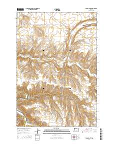
2014 Map of Turner Butte
USGS Topo · Published 2014About this map
Turner Butte and the surrounding high plateau country of Sherman and Gilliam counties define this landscape just south of the Columbia River. The area is characterized by deep drainage systems like Alkali Canyon and Scott Canyon that cut through the basalt layers toward the John Day River in the southwestern corner. This 2014 survey shows a sparsely populated region of the Pacific Northwest where land use is marked by large-scale geographical features such as Shutler Flat and prominent peaks including Butcher Butte and Diamond Butte. A network of rural routes, including Blalock Canyon Rd and Hay Canyon Rd, provides access to these isolated sections. The presence of Cedar Spring and the meandering path of Rock Creek highlight the vital, though limited, water sources in this dry, upland environment.
Find a feature on this map
20 named features on this map. Tap any name to fly to it.
Don’t see what you’re looking for? This feature index may not catch every label — zoom into the map to look around manually.
Map Details
Editions of this 2014 Turner Butte Map
This is the sole edition of this map. No revisions or reprints were ever made.
Other maps of this area

1916 · Arlington
USGS Topo · 1:125,000

1916 · Condon
USGS Topo · 1:125,000

1953 · The Dalles
USGS Topo · 1:250,000

1956 · The Dalles
USGS Topo · 1:250,000

1957 · The Dalles
USGS Topo · 1:250,000

1964 · Turner Butte
USGS Topo · 1:24,000

1964 · Shutler Flat
USGS Topo · 1:24,000

1964 · Mc Donald
USGS Topo · 1:24,000

1970 · Devils Backbone
USGS Topo · 1:24,000
1970 · Mikkalo
USGS Topo · 1:24,000