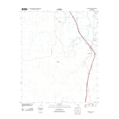
2012 Map of Turner Falls
USGS Topo · Published 2012About this map
Turner Falls and the surrounding Arbuckle Mountains define this section of Murray County, where dramatic elevation changes create numerous cascades. This landscape is shaped by the descent of Honey Cr and Lick Cr toward the Washita River, featuring notable landmarks such as Bridal Veil Falls, Classen Falls, and Lick Creek Falls. The area serves as a significant recreational and organizational hub, centered around the YMCA Camp Classen Number 1-Reservoir and its companion Number 2-Reservoir. Small residential clusters like Jollyville and Cedar Village sit near the river valley, while the uplands include features like Horseshoe Mtn and Horseshoe Spring. The northern reaches of the map include the Green Hill Cem, providing a point of interest for those researching local family histories in this part of Oklahoma.
Find a feature on this map
37 named features on this map. Tap any name to fly to it.
Don’t see what you’re looking for? This feature index may not catch every label — zoom into the map to look around manually.
Map Details
Editions of this 2012 Turner Falls Map
This is the sole edition of this map. No revisions or reprints were ever made.
Other maps of this area

1898 · Pauls Valley
USGS Topo · 1:125,000

1901 · Ardmore
USGS Topo · 1:125,000

1902 · Pauls Valley
USGS Topo · 1:125,000

1918 · Ardmore
USGS Topo · 1:125,000

1957 · Ardmore
USGS Topo · 1:250,000

1963 · Ardmore
USGS Topo · 1:250,000
1964 · Gene Autry
USGS Topo · 1:24,000

1964 · Springer
USGS Topo · 1:24,000

1964 · Turner Falls
USGS Topo · 1:24,000

1965 · Davis
USGS Topo · 1:24,000