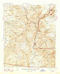
1933 Map of Turret Peak
USGS Topo · Published 1947About this map
Verde River hydrology and early copper mining define this 1930s landscape across the intersection of Yavapai, Gila, and Maricopa counties. The river acts as a central spine, passing the Power Plant and Verde Hot Springs, while high-elevation settlements like Strawberry sit at the edge of the Coconino National Forest. The rugged terrain is punctuated by significant mining operations, including the Copper Queen Mine and United Arizona Mine near Cornstalk Flat.
Find a feature on this map
164 named features on this map. Tap any name to fly to it.
Don’t see what you’re looking for? This feature index may not catch every label — zoom into the map to look around manually.
Map Details
Editions of this 1933 Turret Peak Map
3 editions found

Other maps of this area

1887 · Verde
USGS Topo · 1:250,000

1887 · Prescott
USGS Topo · 1:250,000

1892 · Verde
USGS Topo · 1:250,000

1892 · Prescott
USGS Topo · 1:250,000

1903 · Bradshaw Mountains
USGS Topo · 1:125,000

1905 · Jerome
USGS Topo · 1:125,000

1907 · Roosevelt
USGS Topo · 1:125,000

1909 · Four Peaks
USGS Topo · 1:125,000

1912 · Roosevelt
USGS Topo · 1:125,000

1923 · Camp Verde
USGS Topo · 1:125,000