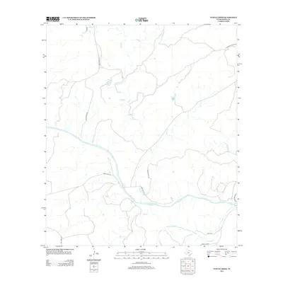
2012 Map of Turtle Creek
USGS Topo · Published 2012About this map
The Llano River meanders across this Hill Country landscape, serving as a primary hydrologic focal point where several significant water sources converge. The area is characterized by numerous spring-fed systems, notably Mill Springs and Kothmann Springs, which indicate the vital groundwater resources of this region. Along the southern boundary, the James River makes a brief appearance, while Turtle Cr and Honey Cr drain the central highlands. The network of rural routes, including Camp Holland Rd and Cross Triangle Rd, reflects a pattern of ranching and land use tied to these water courses. This 2012 survey provides a clear view of the topographical relationship between the river valleys and the upland ranch roads, documenting the persistent rural character of Mason County.
Find a feature on this map
19 named features on this map. Tap any name to fly to it.
Don’t see what you’re looking for? This feature index may not catch every label — zoom into the map to look around manually.
Map Details
Editions of this 2012 Turtle Creek Map
This is the sole edition of this map. No revisions or reprints were ever made.
Other maps of this area

1887 · Mason
USGS Topo · 1:125,000

1894 · Mason
USGS Topo · 1:125,000

1954 · Llano
USGS Topo · 1:250,000

1955 · Llano
USGS Topo · 1:250,000

1956 · Llano
USGS Topo · 1:250,000

1962 · Purdy Hill
USGS Topo · 1:24,000
1967 · Panther Creek
USGS Topo · 1:24,000
1967 · Mason
USGS Topo · 1:24,000
1967 · Monument Mountain SE
USGS Topo · 1:24,000

1968 · Monument Mountain
USGS Topo · 1:24,000