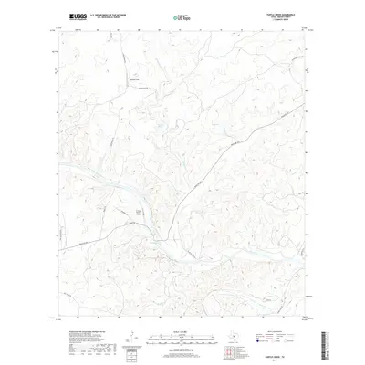
2019 Map of Turtle Creek
USGS Topo · Published 2019About this map
The Llano River winds through this section of the Texas Hill Country, joined by the James River in the southeast corner. The landscape is defined by its complex drainage network, where Turtle Cr and Honey Cr cut through the terrain to meet the larger river valley. Ranching infrastructure and private aviation footprints are evident, most notably at the B Flying Ranch Airport and Snowden Field. Local water sources like Kothmann Springs and Mill Springs indicate the vital role of natural springs in this arid environment, while the presence of Zesch Lake provides a rare stationary water body. Transportation in this part of Mason County relies on a network of ranch roads, including Ranch Rd 1871 and Camp Holland Rd, which navigate the elevation changes dictated by the river's path.
Find a feature on this map
25 named features on this map. Tap any name to fly to it.
Don’t see what you’re looking for? This feature index may not catch every label — zoom into the map to look around manually.
Map Details
Editions of this 2019 Turtle Creek Map
This is the sole edition of this map. No revisions or reprints were ever made.
Other maps of this area

1887 · Mason
USGS Topo · 1:125,000

1894 · Mason
USGS Topo · 1:125,000

1954 · Llano
USGS Topo · 1:250,000

1955 · Llano
USGS Topo · 1:250,000

1956 · Llano
USGS Topo · 1:250,000

1962 · Purdy Hill
USGS Topo · 1:24,000
1967 · Panther Creek
USGS Topo · 1:24,000
1967 · Mason
USGS Topo · 1:24,000
1967 · Monument Mountain SE
USGS Topo · 1:24,000

1968 · Monument Mountain
USGS Topo · 1:24,000