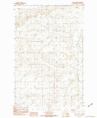
1983 Map of Turtle Creek
USGS Topo · Published 1983About this map
Amelia Poe stands as a prominent terrain feature in this high-plains landscape of McCone County, where a complex network of coulees and creeks defines the drainage of the Missouri River watershed. This 1983 provisional survey shows a region carved by seasonal watercourses, including the West Fork and Middle Fork of Remuda Creek. The inclusion of a remote Airstrip suggests the necessity of light aircraft for navigating these expansive rangelands. Transport in the early 1980s was limited to unimproved roads and trails that intersect at landmarks like Four Corners in the north. The drainage pattern is particularly intricate along Turtle Creek and Big Muddy Creek, illustrating the natural erosion processes that have shaped this portion of eastern Montana's prairie landscape.
Find a feature on this map
12 named features on this map. Tap any name to fly to it.
Don’t see what you’re looking for? This feature index may not catch every label — zoom into the map to look around manually.
Map Details
Editions of this 1983 Turtle Creek Map
This is the sole edition of this map. No revisions or reprints were ever made.
Other maps of this area

1915 · Frazer
USGS Topo · 1:62,500

1915 · Oswego
USGS Topo · 1:62,500

1954 · Jordan
USGS Topo · 1:250,000

1954 · Glendive
USGS Topo · 1:250,000

1954 · Wolf Point
USGS Topo · 1:250,000

1954 · Glasgow
USGS Topo · 1:250,000

1956 · Jordan
USGS Topo · 1:250,000

1957 · Glasgow
USGS Topo · 1:250,000

1957 · Glendive
USGS Topo · 1:250,000

1958 · Wolf Point
USGS Topo · 1:250,000