
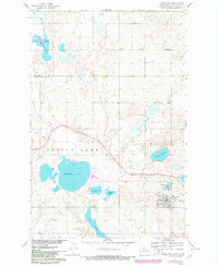
1961 Map of Turtle Lake
USGS Topo · Published 1963About this map
The town of Turtle Lake serves as the focal point for this McLean County survey, situated at the terminus of a Northern Pacific railroad spur. This 1961 field-checked map illustrates a landscape defined by its numerous glacial potholes and wetlands, including the northern Lake Nettie National Wildlife Refuge and the substantial waters of Turtle Lake. The prairie terrain is dotted with small-scale resource extraction and rural institutions, such as a lone Mine near Cherry Lake and the St Olaf Ch in the northeast. This era shows the local infrastructure of the mid-20th century, where local education was still decentralized at sites like School No 2 and School No 3. The township grid is well-established, with drainage patterns reflected in features like Kasper Slough and Turtle Creek, which meanders south from the lake that shares its name toward the Missouri River Basin.
Find a feature on this map
22 named features on this map. Tap any name to fly to it.
Don’t see what you’re looking for? This feature index may not catch every label — zoom into the map to look around manually.
Map Details
Editions of this 1961 Turtle Lake Map
2 editions found
Other maps of this area

1929 · Coleharbor
USGS Topo · 1:62,500

1947 · Turtle Lake
USGS Topo · 1:62,500

1949 · Turtle Creek
USGS Topo · 1:62,500

1949 · Washburn
USGS Topo · 1:62,500

1954 · McClusky
USGS Topo · 1:250,000

1958 · McClusky
USGS Topo · 1:250,000

1961 · Lake Nettie
USGS Topo · 1:24,000

1961 · Turtle Creek NE
USGS Topo · 1:24,000

1961 · Washburn NE
USGS Topo · 1:24,000
1961 · Peterson Lake
USGS Topo · 1:24,000