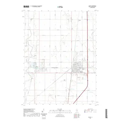
2021 Map of Tuscola
USGS Topo · Published 2021About this map
The city of Tuscola serves as the focal point of this Douglas County landscape, showing a dense grid of residential streets and the Tuscola Township Cem on its southern edge. This 2021 survey illustrates a region where industrial infrastructure and traditional agriculture coexist, exemplified by the National Petroleum Chemical Company Plant Reservoir near the settlement of Ficklin. Local aviation is represented by the Tuscola Airport, situated just west of the main town center.
Find a feature on this map
81 named features on this map. Tap any name to fly to it.
Don’t see what you’re looking for? This feature index may not catch every label — zoom into the map to look around manually.
Map Details
Editions of this 2021 Tuscola Map
This is the sole edition of this map. No revisions or reprints were ever made.
Other maps of this area

1935 · Arcola
USGS Topo · 1:48,000

1936 · Oakland
USGS Topo · 1:48,000

1940 · Arcola
USGS Topo · 1:62,500

1942 · Oakland
USGS Topo · 1:62,500

1950 · Tuscola
USGS Topo · 1:62,500

1956 · Villa Grove
USGS Topo · 1:62,500

1958 · Decatur
USGS Topo · 1:250,000

1961 · Decatur
USGS Topo · 1:250,000
1975 · Tuscola NE
USGS Topo · 1:24,000
1975 · Tuscola NW
USGS Topo · 1:24,000