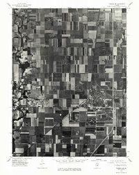
1975 Map of Tuscola SE
USGS Topo · Published 1977About this map
Tuscola serves as the primary urban center in this 1975 orthophoto, where the dense residential grid contrasts sharply with the vast, rectilinear expanse of Douglas County farmland. The imagery, captured during an October 3, 1975, aerial survey, provides a rare look at the structural layout of the region before further modern expansion. This orthophotographic perspective reveals the specific field patterns and rural development that defined the local agricultural economy of the mid-1970s. North of the town, the small community of Hayes sits along the rail line, while the winding course of the Kankaskia river cuts a dark, wooded path through the northwestern section of the map. Unlike standard topographic sheets, this photo-based map allows for the direct observation of woodlots, farmsteads, and industrial footprints exactly as they existed at the time of the flight.
Find a feature on this map
3 named features on this map. Tap any name to fly to it.
Don’t see what you’re looking for? This feature index may not catch every label — zoom into the map to look around manually.
Map Details
Editions of this 1975 Tuscola SE Map
This is the sole edition of this map. No revisions or reprints were ever made.
Other maps of this area

1935 · Arcola
USGS Topo · 1:48,000

1936 · Oakland
USGS Topo · 1:48,000

1940 · Arcola
USGS Topo · 1:62,500

1942 · Oakland
USGS Topo · 1:62,500

1950 · Tuscola
USGS Topo · 1:62,500

1956 · Villa Grove
USGS Topo · 1:62,500

1958 · Decatur
USGS Topo · 1:250,000

1961 · Decatur
USGS Topo · 1:250,000
1975 · Tuscola NE
USGS Topo · 1:24,000
1975 · Tuscola NW
USGS Topo · 1:24,000