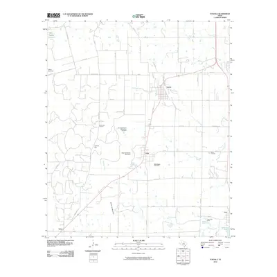
2010 Map of Tuscola
USGS Topo · Published 2010About this map
Tuscola and Ovalo anchor this Central Texas landscape, where the Jim Ned Valley meets the high ridges of the Edwards Plateau. The drainage of Jim Ned Creek and its tributaries, such as Red Bank Creek and Cedar Creek, dictates the placement of long-standing ranching routes like Jones Ranch Rd and Rode Ranch Rd. Evidence of 20th-century water management is visible at the Soil Conservation Service Site 17b1 Dam and Lake Stith Dam.
Find a feature on this map
58 named features on this map. Tap any name to fly to it.
Don’t see what you’re looking for? This feature index may not catch every label — zoom into the map to look around manually.
Map Details
Editions of this 2010 Tuscola Map
This is the sole edition of this map. No revisions or reprints were ever made.
Other maps of this area

1890 · Abilene
USGS Topo · 1:125,000

1892 · Abilene
USGS Topo · 1:125,000

1954 · Abilene
USGS Topo · 1:250,000

1957 · Kirby Lake
USGS Topo · 1:62,500

1957 · Buffalo Gap
USGS Topo · 1:62,500

1958 · Abilene
USGS Topo · 1:250,000

1967 · Tuscola
USGS Topo · 1:24,000
1967 · Lake Abilene
USGS Topo · 1:24,000
1967 · Lawn
USGS Topo · 1:24,000
1967 · Goldsboro
USGS Topo · 1:24,000