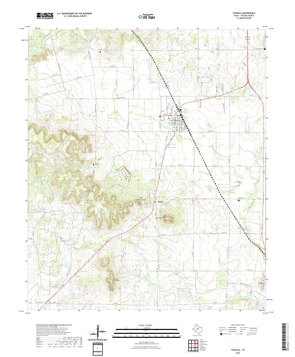
2022 Map of Tuscola
USGS Topo · Published 2022About this map
Tuscola and Ovalo anchor this landscape south of the Callan Plateau, where the plains give way to prominent elevations like Bald Eagle Mtn and High Lonesome Mtn. This modern survey reveals a region defined by its traditional small-town centers and the numerous family-named burial grounds that speak to generations of settlement, including Snodgrass Cem and Booker Cem. The topography is particularly striking at Lemons Gap, where the terrain rises sharply from the winding course of Jim Ned Cr. The map details a complex grid of rural routes, such as Co RD 151 and Co RD 167, which link isolated homesteads and ranch lands. Further south, the community of Lawn sits near the banks of Red Bank Cr, illustrating the historical importance of these intermittent watercourses to the development of Taylor County's agricultural and ranching infrastructure.
Find a feature on this map
76 named features on this map. Tap any name to fly to it.
Don’t see what you’re looking for? This feature index may not catch every label — zoom into the map to look around manually.
Map Details
Editions of this 2022 Tuscola Map
This is the sole edition of this map. No revisions or reprints were ever made.
Other maps of this area

1890 · Abilene
USGS Topo · 1:125,000

1892 · Abilene
USGS Topo · 1:125,000

1954 · Abilene
USGS Topo · 1:250,000

1957 · Kirby Lake
USGS Topo · 1:62,500

1957 · Buffalo Gap
USGS Topo · 1:62,500

1958 · Abilene
USGS Topo · 1:250,000

1967 · Tuscola
USGS Topo · 1:24,000
1967 · Lake Abilene
USGS Topo · 1:24,000
1967 · Lawn
USGS Topo · 1:24,000
1967 · Goldsboro
USGS Topo · 1:24,000