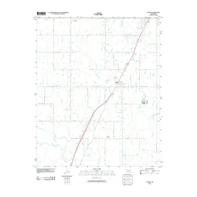
2010 Map of Tushka
USGS Topo · Published 2010About this map
Tushka serves as the central hub of this Atoka County landscape, situated where the modern highway corridor intersects older local routes like W Boggy Depot Rd. The geography is defined by a dense network of watercourses, most notably Clear Boggy Creek and its many tributaries, including Big Branch and Fronterhouse Creek. These drainage patterns shaped the placement of early settlements and rural infrastructure. Genealogists will find significant value in the documentation of three distinct burial grounds: Plainview Cemetery to the north, Tushka Cemetery near the town center, and High Hill Cemetery located further south near High Hill. The road network, including uniquely named paths like W Chicken Fight Rd and Katy Rd, reflects a mix of modern county planning and historical property divisions that have persisted into the 21st century.
Find a feature on this map
35 named features on this map. Tap any name to fly to it.
Don’t see what you’re looking for? This feature index may not catch every label — zoom into the map to look around manually.
Map Details
Editions of this 2010 Tushka Map
This is the sole edition of this map. No revisions or reprints were ever made.
Other maps of this area

1899 · Atoka
USGS Topo · 1:125,000

1900 · Atoka
USGS Topo · 1:125,000

1956 · Stringtown
USGS Topo · 1:24,000

1957 · Lehigh
USGS Topo · 1:24,000

1957 · Bruno
USGS Topo · 1:24,000

1957 · Ardmore
USGS Topo · 1:250,000

1963 · Ardmore
USGS Topo · 1:250,000
1969 · Boggy Depot
USGS Topo · 1:24,000

1969 · Caddo North
USGS Topo · 1:24,000
1969 · Tushka
USGS Topo · 1:24,000