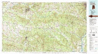
1981 Map of Tuskegee
USGS Topo · Published 1982About this map
Tuskegee Institute stands as a focal point in the northwest quadrant of this region, surrounded by the wooded expanses of the Tuskegee National Forest. The landscape is defined by an intricate network of waterways, including the Tallapoosa River and the meandering Uphapee Creek, which feed into the low-lying Big Swamp central to the map. This area illustrates the transition from the upland forests of Macon County to the riverine borders of the Chattahoochee River near Phenix City.
Find a feature on this map
110 named features on this map. Tap any name to fly to it.
Don’t see what you’re looking for? This feature index may not catch every label — zoom into the map to look around manually.
Map Details
Editions of this 1981 Tuskegee Map
2 editions found
Other maps of this area

1901 · Wetumpka
USGS Topo · 1:125,000

1901 · Wetumpka
USGS Topo · 1:62,500

1903 · Wetumpka
USGS Topo · 1:125,000

1906 · Dadeville
USGS Topo · 1:125,000

1907 · Talbotton
USGS Topo · 1:125,000

1907 · Opelika
USGS Topo · 1:125,000

1908 · Columbus
USGS Topo · 1:62,500

1909 · Opelika
USGS Topo · 1:125,000

1914 · Seale
USGS Topo · 1:62,500

1929 · Columbus
USGS Topo · 1:48,000