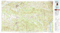
1981 Map of Tuskegee
USGS Topo · Published 1982About this map
Tuskegee Institute and its surrounding historic landscape are the focal point of this regional study, which also highlights the critical role of Moton Field and the Veterans Administration Hospital. The map reveals a complex web of 20th-century transportation and conservation, where the Western Railway of Alabama and Central of Georgia cut through the timberlands of the Tuskegee National Forest.
Find a feature on this map
127 named features on this map. Tap any name to fly to it.
Don’t see what you’re looking for? This feature index may not catch every label — zoom into the map to look around manually.
Map Details
Editions of this 1981 Tuskegee Map
2 editions found
Other maps of this area

1901 · Wetumpka
USGS Topo · 1:125,000

1901 · Wetumpka
USGS Topo · 1:62,500

1903 · Wetumpka
USGS Topo · 1:125,000

1906 · Dadeville
USGS Topo · 1:125,000

1907 · Talbotton
USGS Topo · 1:125,000

1907 · Opelika
USGS Topo · 1:125,000

1908 · Columbus
USGS Topo · 1:62,500

1909 · Opelika
USGS Topo · 1:125,000

1914 · Seale
USGS Topo · 1:62,500

1929 · Columbus
USGS Topo · 1:48,000