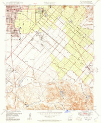
1948 Map of Tustin
USGS Topo · Published 1957About this map
The growing town of Tustin serves as the focal point for this late 1940s landscape, where residential blocks transition into the extensive agricultural operations of Irvine Ranch. This era shows a distinctive blend of citrus-era development and emerging infrastructure, featuring the sprawling Naval Reservation and the early footprint of the Orange County Airport. Educational institutions like Tustin High Sch and Delhi Sch mark the community hubs of the time, while the Atchison Topeka and Santa Fe railroad line connects the commercial centers of Santa Ana and Irvine.
Find a feature on this map
59 named features on this map. Tap any name to fly to it.
Don’t see what you’re looking for? This feature index may not catch every label — zoom into the map to look around manually.
Map Details
Editions of this 1948 Tustin Map
2 editions found
Other maps of this area

1896 · Santa Ana
USGS Topo · 1:62,500

1896 · Anaheim
USGS Topo · 1:62,500

1898 · Anaheim
USGS Topo · 1:62,500

1901 · Southern California Sheet No. 1
USGS Topo · 1:250,000

1901 · Santa Ana
USGS Topo · 1:62,500

1901 · Anaheim
USGS Topo · 1:62,500

1902 · Corona
USGS Topo · 1:125,000

1904 · Southern California Sheet No. 1
USGS Topo · 1:250,000

1932 · Orange
USGS Topo · 1:31,680

1932 · Newport Beach
USGS Topo · 1:31,680