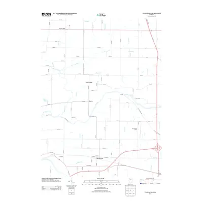
2013 Map of Twelve Mile
USGS Topo · Published 2013About this map
The Wabash River and Eel River systems anchor this north-central Indiana landscape, where water management defines the agricultural character of the region. A dense network of drainage channels, including Ulerich Ditch, Lowe Ditch, and Grable Ditch, reveals the intensive effort required to maintain the fertile tillable land between these major waterways. The settlement pattern is concentrated in small crossroads like Twelve Mile and New Waverly, which sit at the periphery of this drainage basin.
Find a feature on this map
75 named features on this map. Tap any name to fly to it.
Don’t see what you’re looking for? This feature index may not catch every label — zoom into the map to look around manually.
Map Details
Editions of this 2013 Twelve Mile Map
This is the sole edition of this map. No revisions or reprints were ever made.
Other maps of this area

1951 · Peru
USGS Topo · 1:24,000

1951 · Onward
USGS Topo · 1:24,000

1951 · Twelve Mile
USGS Topo · 1:24,000

1951 · Bunker Hill
USGS Topo · 1:24,000

1953 · Danville
USGS Topo · 1:250,000

1955 · Danville
USGS Topo · 1:250,000

1955 · Logansport
USGS Topo · 1:24,000

1955 · Anoka
USGS Topo · 1:24,000

1956 · Danville
USGS Topo · 1:250,000
1960 · Peru
USGS Topo · 1:24,000